GIS | Spatial Analysis | Remote Sensing | Cartography | Data Analytics | Environmental Research
Technical Communication | Data Visualization & Communication | Graphic Design
Featured Projects
Project Date: 2025
Portfolio Update: 2026
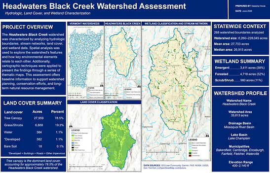
Headwaters Black Creek Watershed Assessment
Hydrologic, Land Cover, and Wetland Characterization
Integrated hydrologic boundaries, stream networks, land cover, and wetland datasets to characterize watershed conditions within Vermont's Headwaters Black Creek watershed. Applied spatial and hydrologic analysis and cartographic techniques in ArcGIS Pro to examine landscape patterns and produce thematic maps and summary statistics supporting watershed planning, conservation, and natural resource management.
Project Context: Originally developed through the University of Vermont's Advanced GIS course (GIS & Data Communication Certificate) and later refined for my professional portfolio.
Software: ArcGIS Pro
Spatial & Hydrologic Analysis: Spatial Analysis, Hydrologic Analysis, Watershed Analysis, Land Cover Analysis
Environmental Applications: Wetland Mapping, Environmental GIS
Cartography & Visualization: Cartography, Data Visualization
Data Management: GIS Data Management
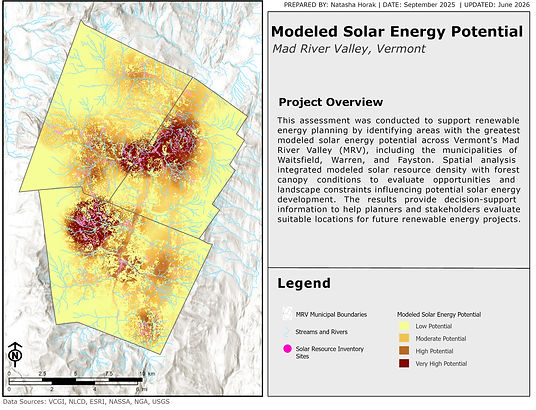
Solar Energy Potential Assessment for Vermont's Mad River Valley
Raster-Based Solar Resource & Land Cover Analysis
Integrated modeled solar resource density with forest canopy data to evaluate patterns of solar energy potential across Vermont's Mad River Valley. Applied raster-based spatial modeling and analysis techniques in ArcGIS Pro to identify areas with varying solar resource potential and produce a decision-support map relevant to renewable energy planning and land management.
Project Context: Originally developed through the University of Vermont's Advanced GIS course (GIS & Data Communication Certificate) and later refined for my professional portfolio.
Software: ArcGIS Pro
Raster & Spatial Analysis: Raster Analysis, Spatial Analysis, Spatial Modeling, Point Density Analysis, Raster Calculator, Conditional (Con) Analysis
Planning Applications: Renewable Energy Planning, Land Suitability Analysis, Environmental GIS
Cartography & Visualization: Cartography, Data Visualization

Residential Site Suitability Assessment for the Winooski River Basin
Multi-Criteria Spatial Analysis for Development Planning
Integrated environmental and development datasets, including canopy cover, residential density, transportation infrastructure, development pressure, and proximity to impaired waterways, to evaluate residential development suitability within Vermont's Winooski River Basin. Applied multi-criteria decision analysis, weighted overlay modeling, raster analysis, and proximity analysis in ArcGIS Pro to identify candidate areas and produce decision-support maps for land use
and environmental planning.
Project Context: Originally developed through the University of Vermont's Advanced GIS course (GIS & Data Communication Certificate) and later refined for my professional portfolio.
Software: ArcGIS Pro
Spatial Modeling & Analysis: Multi-Criteria Decision Analysis (MCDA), Site Suitability Analysis, Spatial Analysis, Weighted Overlay Analysis, Raster Analysis, Zonal Statistics, Point Density Analysis, Euclidean Distance Analysis
Planning Applications: Environmental Planning, Land Use Planning
Data Integration: Data Integration
Cartography & Visualization: Cartography, Data Visualization

Variable-Distance Buffer Analysis for Land Use Planning
Automated Spatial Analysis Using ArcGIS Pro ModelBuilder
Developed an automated geoprocessing workflow to generate variable-distance buffers around recreational and community points of interest within Vermont's Mad River Valley. Applied ArcGIS Pro ModelBuilder, iterative processing, and user-defined parameters to create a repeatable spatial analysis workflow, improve processing efficiency, and produce decision-support maps for land use and recreation planning.
Project Context: Originally developed through the University of Vermont's Advanced GIS course (GIS & Data Communication Certificate) and later refined for my professional portfolio.
Software: ArcGIS Pro, ModelBuilder, Workflow Automation: GIS Workflow Automation, GIS Workflow Design, Iterative Processing, Model Parameters
Spatial Analysis & Geoprocessing: Geoprocessing, Spatial Analysis, Buffer Analysis
Planning Applications: Land Use Planning, Recreation Planning, Spatial Decision Support
Cartography & Visualization: Cartography, Data Visualization
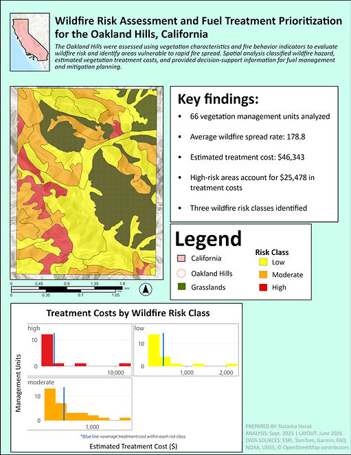
Wildfire Risk Classification & Fuel Treatment Cost Analysis
Vegetation Risk Classification & Treatment Cost Analysis
Evaluated vegetation characteristics and wildfire behavior indicators to classify wildfire risk across vegetation management units in the Oakland Hills, California. Applied vector analysis, attribute queries, geoprocessing, and field calculations in ArcGIS Pro to estimate vegetation treatment costs by risk class and produce decision-support maps and charts supporting fuel reduction planning, wildfire mitigation, and natural resource management.
Project Context: Originally developed through the University of Vermont's Advanced GIS course (GIS & Data Communication Certificate) and later refined for my professional portfolio.
Software: ArcGIS Pro
Spatial & Data Analysis: Spatial Analysis, Vector Analysis, Attribute Queries (SQL), Geoprocessing, Field Calculations, Data Classification
Environmental Applications: Wildfire Risk Assessment, Fuel Treatment Planning, Natural Resource Management
Decision Support: Cost Analysis, Treatment Prioritization
Cartography & Visualization: Cartography, Data Visualization